
Whether you’re active in agricultural monitoring, studying climate change impact or even modelling green energy installations, there’s an important element to determine the quality and success of your work. And that’s accurate and spatially detailed maps on land cover and land use.
Luckily that’s our field of expertise. So today we are extremely thrilled to release the new Copernicus Global Land Cover maps at ESA’s biggest Earth observation conference ‘Living Planet Symposium 2019′. Thanks to a new novel mapping approach we offer typical discrete maps as well as continuous cover fraction layers for all 9 base classes making it possible to tailor the maps to the user’s specific needs.
The need for accurate and detailed land cover maps
The Copernicus Global Land Service, one of the 6 Copernicus services, assists public and private organizations in the preservation of our ecosystems. At the end of 2017, we released the Africa land cover map. We produced this map with a novel land cover mapping approach which produces next to a typical discrete map also continuous cover fraction layers for forest, grassland, shrub, and bare. Each cover layer provides the fraction of the pixel that belongs to the given class making it possible to tailor the land cover map to your specific needs.
Now we scaled up and extended our portfolio with the new Global Land Cover Layers, a discrete map and 10 continuous cover fractions (9 base land cover classes and seasonal water) to provide spatial information about land for a diversity of applications ranging from global forest monitoring, global crop monitoring, biodiversity and nature conservation to climate modelling.
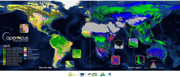
This collage shows the global discrete classification for the year 2015 (left side)
and an example of combining 3 out of 9 cover fraction layers into a False Color Composite (FCC – right side).
The Copernicus Global Land Cover product is matured from a continental demonstration to a full global service. This means that, next to the global discrete map and the cover fraction layers, the service will provide you yearly updates and land cover change maps. This will allow you and other users to overcome the restrictions of current land cover products and to build your own customized and project optimized land cover classification maps. You can access in total 20 single layers in our product:
- Full discrete classification (23 classes )
- Fraction cover layers for ten base land cover classes
- False colour composites to highlight from one class to the next (e.g. combine grass, forest and shrub to show natural vegetation)
- Quality indicators for the input data and applied algorithms
From static to elastic land cover maps
Land cover maps are used by various user groups to better understand the current landscapes and the impact we have as global citizens. But at the same time, static land cover maps are often hard to use in different applications. The variety in needs make it hard to create a one-size-fits-all land cover map. We need more elastic land cover mapping approaches to guarantee high quality products for each user.
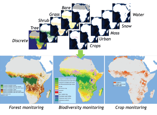
By adding 10 fractional cover layers, users can now extend the base classification with classes tuned to their specific needs. With our new methodology you can create individual land cover maps in high resolution tailored to your needs. Whether you need forest maps or grassland maps, this innovative approach lets you decide and gives the objective information you’re looking for.
Let me give you a short overview of the most important improvements.
- Accuracy:
The global overall accuracy of the product for the base year 2015 was calculated through an independent pre-validation an reached 80% (a detailed global and continental validation report is expected in summer 2019). - New improved Proba-V archive:
To reduce distortion in the High North, to make our land cover products better usable with other data and to allow continuity of the service, the Proba-V archive used as current main input data source was reprocessed with a new geometric correction and an improved atmospheric correction. The complete Proba-V archive was in this way translated into the Proba-V UTM ARD (Analysis Ready Data) which is produced in UTM (Universal Transverse Mercator) coordinate system and fully aligned with the Sentinel-2 tiling grid in tiling naming as well as tile dimensions. - Multi-sensor usage:
The new workflow is modular and designed for multi-sensor usage meaning that land cover classifications using different satellite data and resolutions are now possible (tested already with regional Sentinel-2 20 m classifications and Landsat 30 m classifications), and will be continued at 100 m through combining Sentinel-2 and Sentinel-1 after the end of the Proba-V mission. - From 4 to 10 continuous cover fractions:
The new product provides for every base land cover class (forest, shrubland, herbaceous vegetation, moss&lichen, bare/sparse vegetation, built-up, cropland, snow&ice, permanent inland water bodies, and seasonal inland water bodies) also a percentage cover fraction layer (also known as Percentage Vegetation Cover (PVC)) – only available for the current 100 m products – hence increasing the PVC from four in the demonstration product to ten covers. - Implementation of improved quality indicators not only for the input data but also for the classification and regression outputs.
The sky is not the limit!
To facilitate our users to access regional and national level statistics, we also release a new land cover viewer. The new Copernicus Global Land Cover viewer not only allows you to visualize all data, but also gives first insights via land cover statistics on GAUL level (UN FAO’s Global Administrative Unit Layer) which can be compared between regions.
Discover the viewer yourself to search, view, compare and download regional and national maps and statistics in just a few clicks.
Leave a Reply